

Consultant archaeologists in Ontario follow a four-stage fieldwork process that is laid out in the Standards and Guidelines for Consultant Archaeologists. These stages are sequential, but not every stage of assessment will need to be carried out for a subject property. The four-stage process is designed to first determine areas of archaeological potential within a subject property; if any areas of the subject property are deemed to exhibit archaeological potential, then the property will undergo a physical assessment to identify any potential archaeological resources that are present. If archaeological resources are identified, their level of cultural heritage value or interest (CHVI) will be evaluated to determine if further archaeological assessment is warranted and what the most suitable strategies for assessment are.
Archaeological Assessments

Stage 1 Archaeological Background Study
This is the initial stage of assessment where the consultant archaeologist reviews the land use, archaeological history and geography of all lands that are a part of the subject property. This information is related to the current conditions of the subject property and then used to determine if any part of the subject property exhibits potential for archaeological resources. A Stage 1 assessment is usually carried out as a desktop assessment. However, a property inspection by a licensed archaeologist is necessary when any portion of the study area is to be excluded from a Stage 2 assessment. Stage 2 Property Assessments are mandatory if any portion of the subject property is deemed to have archaeological potential. If, through the course of a Property Inspection, the entirety of the subject property is deemed to not retain any archaeological potential, then no further archaeological work is required.

Stage 2 Property Assessment
A Stage 2 Property Assessment is the next stage of assessment if a Stage 1 determines that a property exhibits archaeological potential. The Stage 2 is the physical assessment of the subject property and is designed to identify any archaeological resources that may be present. Often times this is paired with a Stage 1 to save clients time and money by conducting one assessment instead of two separate assessments. This is called a Stage 1-2 assessment. Standard Stage 2 methodology consists of either shovel testing, pedestrian survey or a combination of both. shovel testing is generally conducted on a grid at either 5m or 10m intervals and takes place in any area that cannot be ploughed, such as old pastures, forested areas, woodlots, residential lawns, etc. Pedestrian survey is also conducted on a grid at either 5m or 2.5m intervals and consists of walking ploughed fields looking for artifacts pulled to the ground surface by a plough. The presence of the artifacts indicates that a subsurface archaeological site at that location is likely. If an archaeological site is identified, an analysis of the artifacts will determine if a Stage 3 Site-Specific Assessment is required.

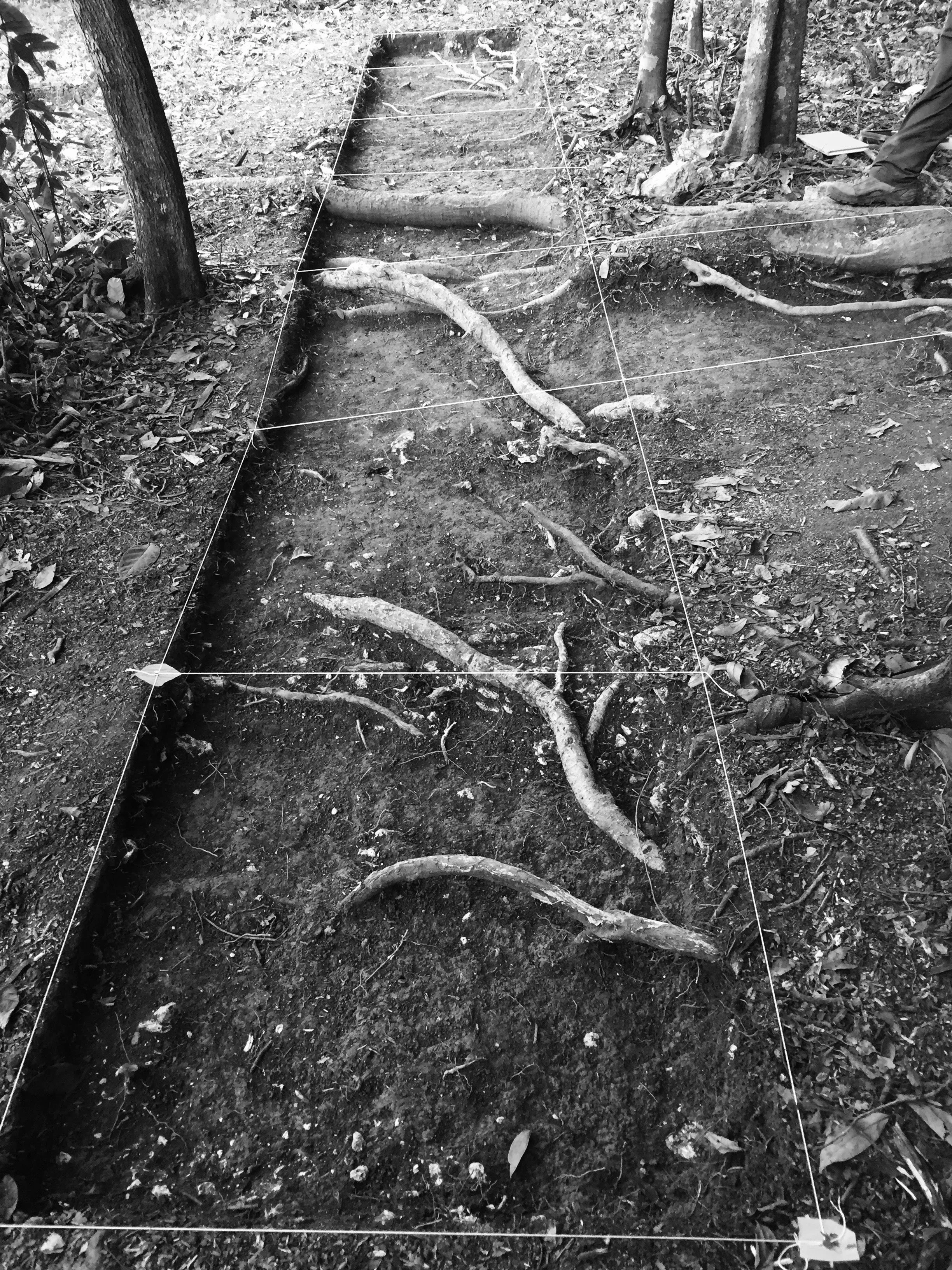
Stage 3 Site-Specific Assessment
A Stage 3 Assessment is a focused assessment of a specific site that has been recommended for further work after the completion of a Stage 1-2 assessment. The Stage 3 assessment is carried out in order to build off of the information gained during the Stage 2 with the goal of determining the spatial extent of the archaeological site, the nature, time period and cultural affiliation of the site, to provide a more robust evaluation of the sites CHVI and to make recommendations for further work or that clears the site of any further archaeological work.
A Stage 3 Site-Specific Assessment consists of excavating a number of 1m by 1m test units or test trenches across the extent of the site. These test units or test trenches are dug in order to test the nature and extent of buried archaeological deposits at the site. The goal is to determine if there are any in-tact, subsurface features related to the occupation/activity at the site and to further refine site dating and cultural affiliation through the collection of additional artifacts. Any features identified during the Stage 3 are not excavated. Instead, they are recorded, photographed and then covered with geotextile fabric and backfilled. Archaeological features are excavated during Stage 4 Mitigation of Development Impacts.
Stage 4 Mitigation of Development Impacts
Stage 4 Mitigation for an archaeological site consists of either preservation/protection of the site through avoidance, excavation of the site or a combination of the two options. Long-term protection strategies for an archaeological site is always preferred; however, if protection of the site is not a viable planning option, then archaeological excavations are necessary to fully document the site and remove any artifacts or archaeological features before development activities begin.
The scope of excavation depends on what was recorded as part of the Stage 3 Site-Specific Assessment. Areas of the site that require further investigation are generally identified during the Stage 3 Site-Specific Assessment. These areas need to be hand excavated, mapped, photographed and drawn. Soil samples are also collected from features which undergo flotation to identify micro floral and faunal remains that would otherwise get screened out using hand excavation methodology. Mechanical topsoil removal can only be used as a method when the site has been subject to ploughing for many years, the site has only one cultural stratum below topsoil, the site is large, the cultural affiliation of the site provides a reasonable expectation that extensive sub-surface features and settlement data may be present and both the Stage 2 and Stage 3 assessments have documented a representative sample of ploughzone artifacts and their distribution. Mechanical topsoil removal cannot be completed below the topsoil/subsoil interface.
Archaeological sites that will be preserved or protected are left as areas of passive use. These areas cannot be impacted by proposed construction activities. Generally, planning measures protect these sites through restrictions that prevent any landscape alterations within the site area unless excavation of the impacted area is carried out prior to any proposed changes.

Indigenous Engagement
Indigenous Engagement is a mandatory component of the archaeological process and is an obligation of the archaeological consultant. Apex Archaeology Inc. takes pride in advocating for Indigenous Engagement on all of its projects and strongly recommends beginning this process from the onset. Apex Archaeology Inc. recognizes how important the engagement process is to First Nations in the treatment of their cultural heritage.
For more information regarding Indigenous Engagement, see Engaging Aboriginal Communities in Archaeology: A Draft Technical Bulletin for Consultant Archaeologists in Ontario. A link to the bulletin webpage is provided below.